
Indigenous Resources
It’s November, and in the United States that means the start of the holiday season with Thanksgiving. It is impossible to celebrate Thanksgiving without acknowledging the role of the Native Americans in that first feast. Or without further acknowledging the shameful treatment of the Native Americans by the early settlers and their descendants.
With that in mind, I want to highlight two collections today that celebrate Indigenous Peoples and seek to make their history and culture known.
I-Portal: Indigenous Studies Portal
To start, let’s look at I-Portal: Indigenous Studies Portal. Created by the University of Saskatchewan, I-Portal is a collection of over 70,000 resources – including articles, audiovisuals, oral histories, reports, and government and archival documents – about Indigenous peoples of Canada, with additional materials on the US, Australia, and Aotearoa/New Zealand.
The portal is browseable by subject or by community (based on a map of Canada). You can also limit searches to Indigenous authors/creators only. Some items provide direct access to full-text. Others give options for Google Scholar, Interlibrary Loan, or – if your university is registered with I-Portal – the option to set your affiliation and search your university library directly from the site.
The Indigenous Digital Archive’s Treaties Explorer
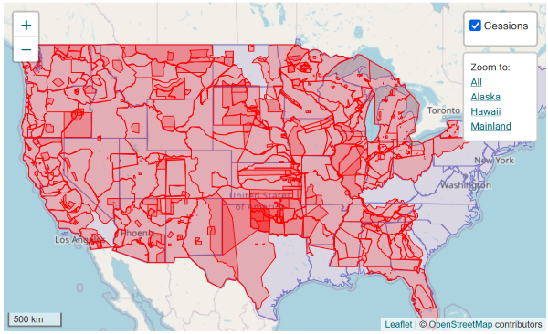
The Indigenous Digital Archive and its Treaties Explorer, aka DigiTreaties.org, is a project of the Museum of Indian Arts and Culture in Santa Fe, New Mexico. Using historic maps and modern GIS data, the site maps the ratified and unratified treaties between the US and the Native American peoples. Since there was no official list of ratified treaties, government clerks in the 1890s and 1900s researched land transfer treaties and agreements and created a list of what they called cessions. These 720 cessions are also included on DigiTreaties.
There are several ways to explore the Treaties Explorer.
By Treaty - All treaties are included here, with image files of the original, along with transcriptions. (3074 items)
By Cession - All 720 cessions are included here. Each cession includes the relevant treaties, sources, and nations, as well as a map of the territory in question.
By Nation - 692 nations, both historic and present day are listed here. You can see a map and list of related cessions and treaties, as well as associated present-day/historic nations. In some cases, a timeline is available showing all the cessions and treaties.
By Place - A map of the United States showing all lands involved in land transfers by cession or treaty. Cessions and treaties are in different map layers (red and blue respectively), and the cessions layer can be toggled on or off.
Looking at the Cessions map, many of the tracts overlap because multiple nations were using the land. For example, at the Alabama-Tennessee border, both the Chickasaw and Cherokee nations hunted the land. Ratified Indian Treaty (RIT) 46 negotiated with the Chickasaw Nation in July 1805, and RIT 53 negotiated with the Cherokee Nation in January 1807 claim this land for the United States.
RIT 46 reserves “a tract of one Mile square adjoining to and below the mouth of Duck River, on the Tennessee for the use of Chief O’Koy or Tishumastubbee.” A single square mile. Imagine.
RIT 53 “cede[s] to the United States all the right, title, and interest which the said Cherokee Nation ever had to a tract of Country contained between the Tennessee river & the Tennessee ridge. (so called): which tract of Country had since the year 1794 been claimed by the Cherokees & the Chickasaws….” I wonder if that square mile they left Chief O’Koy was included in this one.
The ability to view these treaties and cessions on a timeline really brings home the cavalier and disrespectful ways in which the colonists slowly and systematically took the land from the Indigenous population. Let’s remember, as we sit down to our turkey and dressing, that we can give thanks for what we have and at the same time acknowledge that our ancestors were bastards.